How Do the 50 States Stack Up According to Their ‘State Avenue Gravitas’ in D.C.?
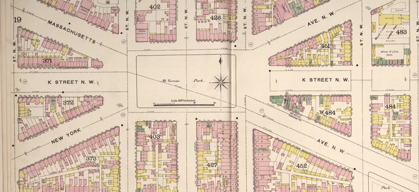
Massachusetts and New York avenues intersect at what is today known as Mt. Vernon Square, as seen in this 1888 Sanborn Fire Insurance map. Library of Congress


Yes, it’s an unusual way to rank the states. But do California and Texas deserve higher-profile D.C. locations because of their outsized populations?
WASHINGTON — On a hot summer day sometime in the mid 2000s, a group of tourists wearing Lone Star Texas T-shirts were looking up at a Pennsylvania Avenue street sign near the Old Post Office Pavilion. I was waiting for a walk signal when I overheard a teenager in the group ask the fatherly-looking figure of the bunch, while pointing at the street sign with the U.S. Capitol’s dome off in the distance: “Where’s Texas Avenue?”
It’s a somewhat hazy memory, but I remember thinking to myself: “That is a good question— where is Texas Avenue?
I knew that the Lone Star State’s D.C. avenue was somewhere east of the Anacostia River, but exactly where was somewhat fuzzy. I had certainly been on Arizona Avenue, near my great aunt’s house, dozens upon dozens of time. I had never stumbled upon Texas Avenue in my D.C. neighborhood explorations.
For a state that has the nation’s second-largest population, Texas does not have a very prominent state-named avenue. Nor does California, the nation’s most populous state. (And California is the only state that has slightly diminished dignity of being simple a “Street,” not an “Avenue.” Meanwhile, one block away is the nation’s least populated state, Wyoming, which is an “Avenue.”
State population size certainly does not determine the location of state-named thoroughfares in the nation’s capital. In this city, a handful of state names occupy some of the most important and widely recognized thoroughfares in the city.
But is there any rhyme or reason to where the 50 states ended up? A quick answer would be “no,” but there are definitely some interesting factors to consider when trying to determine where the states stack up based on locational factors.
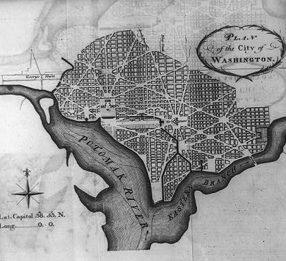
The older the state, the more likely it occupies one of the more lucrative diagonal avenue alignments in the original L’Enfant-designed city. Seven lucky states have their avenue’s alignments radiate from the White House and U.S. Capitol, envisioned as the two main nodes of power in the capital city. That includes Pennsylvania Avenue, which connects the two. As more states were added to the Union, their names eventually were added to the map as the nation’s capital expanded beyond its original city. In 1871, Washington County and the City of Georgetown were unified with the City of Washington to form a single D.C. government through the District of Columbia Organic Act.
What if you could rank the 50 states based on the location and characteristics of their corresponding state-named avenue in the District of Columbia? Essentially, this would be a measure of state identity gravitas—if that is something that could be indeed measured.
Let’s give it a shot!
Background and Methodology
State avenue gravitas is something I’ve considered on a handful of occasions since an early age looking at a fold-out District of Columbia street map I had as a child visiting relatives in the nation’s capital. (My family has District roots going back to the 1860s.)
Certain states got seemingly way more lucrative spots on the map, like, obviously, Pennsylvania Avenue. Others ended up in obscure places, Hawaii Avenue, for instance, adjacent to the Catholic University of America's athletic fields.
Granted the Aloha State was a very late entrant to the Union, compared to Pennsylvania, which was one of the originally 13 American colonies. So it only makes sense that Hawaii would end up with a less-prominent location in the nation’s capital.
Over the past decade or so and I devised a way to measure where the states stack up based on their D.C. locations. Over the course of many years, I’ve been to all 50 state-named thoroughfares in D.C., and in 2012, drove to 49 states all in one day, foolishly skipping over Oklahoma Avenue during my complicated journey around the District. Recently, I decided to run the 50 states through my state-avenue gravitas methodology again.
After crunching the numbers a handful of times, I know that no two state avenues were created alike. They come in many shapes and sizes, from monumental boulevards with plenty of landmarks and points of interest to quiet and unassuming curving suburban-style residential streets you might always miss unless you purposefully went there to check it off a 50-state list.
Along the way, some politics got mixed into naming process, most notably, perhaps, was a U.S. senator from Georgia who wanted the state he represented have a location in a better part of town. (Georgia Avenue moved from what is today’s Potomac Avenue in the District’s Southwest and Southeast quadrants to its location today, the 7th-longest avenue in the city.)
For detailed backgrounders on D.C.’s street-naming patterns, Curbed DC and Greater Greater Washington have previously explored the topic of D.C. street naming.
But here’s my addition to the discussion: Which states have the best or worst avenues in the nation’s capital? I’ve devised a point system to measure “state-avenue gravitas” based on handful of geographic and other characteristics.
Here’s my methodology, which I should note is limited to the 50 states and does not factor in District of Columbia or other U.S. territories. (There is a Puerto Rico Avenue, which serves as a railroad frontage road in the District’s Northeast quadrant.)
How many quadrants does the state avenue pass through? Most state avenues exist within only one of the District’s four directional quadrants—Northwest, Northeast, Southeast, Southwest, which meet at the U.S. Capitol. A handful of state avenues cross quadrant boundaries. (There are only two states that exist in three of the four quadrants: Massachusetts and Virginia.) 2 points per quadrant.
Is the state an “Original 13” colony?
The early birds got the worms. So Connecticut, Delaware, Georgia (since relocated), New Hampshire, New Jersey, New York, Maryland, Massachusetts, North Carolina, Pennsylvania, Rhode Island, South Carolina and Virginia are in the “Original 13” club. Although Vermont is one of the four states to have an avenue that radiates from the White House, Vermont is the 14th state. 4 points for being in the Original 13. Sorry Vermont—at least you have full and equal representation in Congress, unlike D.C. residents.
Is the state-named thoroughfare in the original L’Enfant-designed city?
States that have their designated thoroughfare on one of the diagonal avenues in the original city—essentially everything south of Florida Avenue and roughly between the Potomac and Anacostia rivers—get additional points. (Ohio Drive, built on parkland reclaimed from Potomac River tidal flats, did not physically exist in the original city and may be the first state to be erased from future maps due to rising sea levels.) 2 points for being inside the original L’Enfant city. Sorry Buckeyes, you may want to consider a trade with Florida, which is safely inland.
Does the state avenue radiate from the White House or U.S. Capitol building?
In the original L’Enfant city plan, grand diagonal avenues radiated from two focal points—the White House, the seat of the Executive Branch, and the Capitol, the seat of the Legislative Branch. There was no designated spot of equal footing for the third branch of government, the Judicial Branch, but the Supreme Court’s building eventually took shape opposite the Capitol at First Street NE & Maryland Avenue. So in this exercise, Maryland is the only state to get additional points from its close proximity to the Supreme Court. 2 points each.
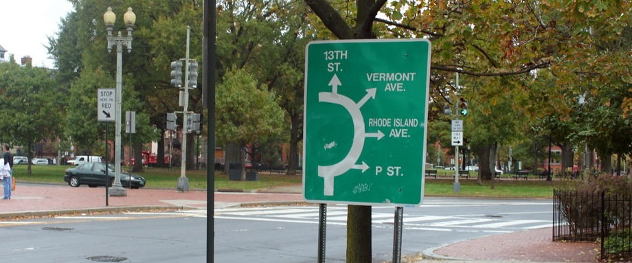
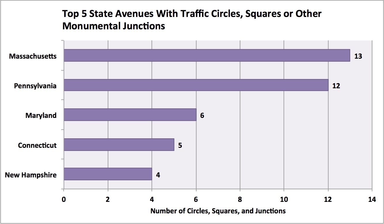
How many important junctions—traffic circles, squares and other potentially monumental intersections—does the state avenue connect?
Thanks to the state-named diagonal avenues that cut across a grid of lettered and numbered streets, the District is home to a lot of non-standard and non-90-degree intersections, including traffic circles, squares and other junctions that can host—and in this city, often do host—a statue, monument or other public space.
For this exercise, named junctions (e.g., Dupont Circle, L’Enfant Square) were used in the count, though I used personal judgment whether to count certain intersections or unnamed public spaces (e.g., the traffic circle at the end of Maryland Avenue outside the Mandarin Oriental Hotel in D.C.’s Southwest quadrant, which I counted).
Also for this exercise, the U.S. Capitol and White House are not considered in this category since they are already the two focal points for the layout of the original L’Enfant city. 1 point per “important junction.”
Here are top states with important junctions like traffic circles and public squares:
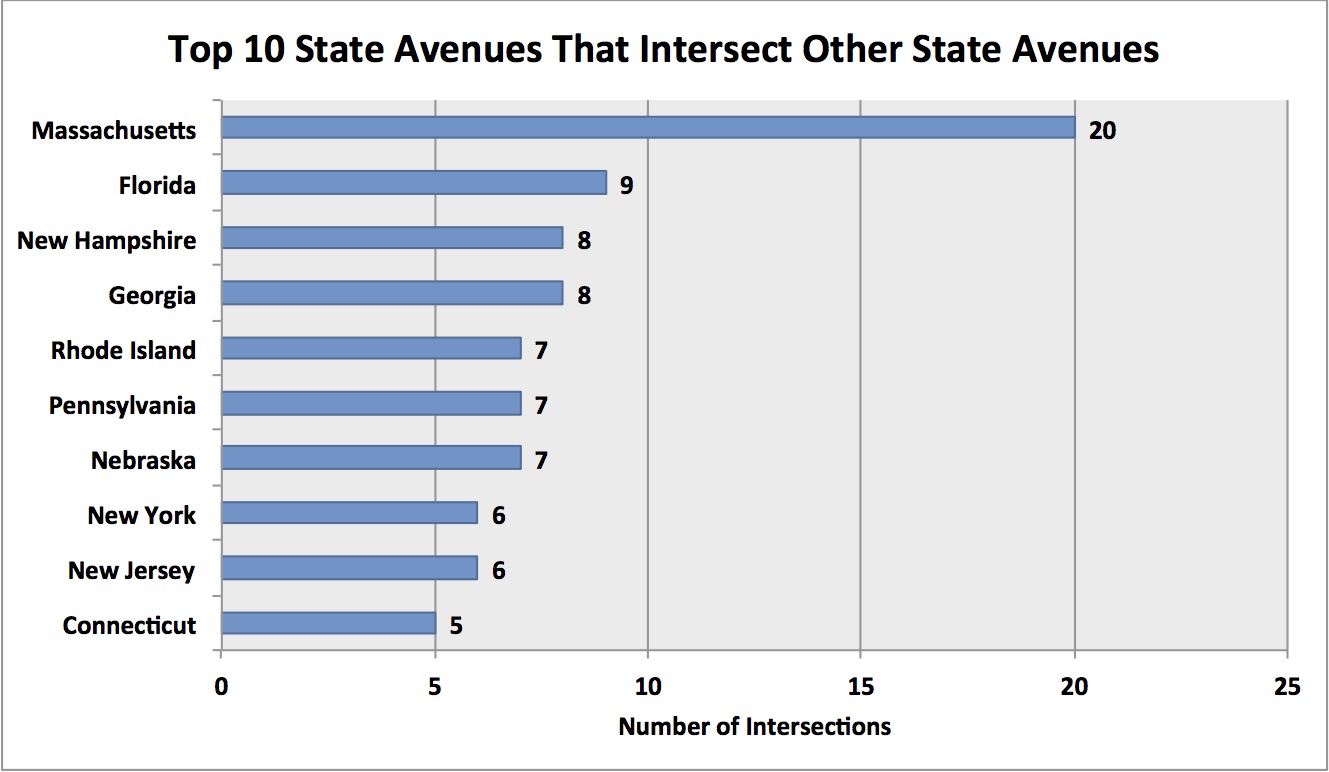
How many intersections are there with other state-named thoroughfares?
One measure of a state’s gravitas on the District’s street layout is the number of times it intersects another state-named thoroughfare. Generally, the longer a state avenue is, the more opportunities it has to cross another state avenue. So it’s no surprise that Massachusetts, the District’s longest state avenue, is No. 1 with 20 other states intersected, followed by Florida (9 other states), Georgia (8 other states), New Hampshire (8 other states) and Nebraska (7 other states), Pennsylvania (7 other states) and Rhode Island (7 other states).
There were some close calls made on whether one state avenue intersected another. For instance, does Indiana Avenue intersect Pennsylvania Avenue? Technically, no. But the alignment of Indiana Avenue meets Pennsylvania Avenue at an important junction in the original L’Enfant City: Market Square, today’s Navy Memorial and National Archives. So the Indiana-Pennsylvania non-junction was counted as a state intersection. Another example: Colorado Avenue’s northern end is at Missouri Avenue, and although it comes very close to meeting Georgia Avenue, a Colorado-Georgia intersection does not count.
Also in this exercise, there’s an exception for avenues that intersect the White House or the Capitol: When counting the number of other state avenues intersected along their alignments, don’t factor in the other avenues that radiate from, but do not actually intersect, at the White House or Capitol—so, Connecticut, Delaware, Maryland, New Jersey, New York, Pennsylvania and Vermont. 1 point for each state intersection.
Here are the top performing states in this category:
Is the state-named thoroughfare physically interrupted?
State-named thoroughfares can sometimes end up in different disconnected segments: New Hampshire Avenue, for instance, has one segment inside the original L’Enfant city and an unconnected segment outside the original city that continues into Maryland.
For this exercise, the White House and Capitol are not considered interruptions because they are two of the focal points in the layout of the original L’Enfant city where many avenues radiate from. Traffic circles and squares are also not considered physical interruptions since they are considered part of a state avenue alignment’s public space footprint. Things like an expressway or federal building counts as an interruption. And interruptions count against an avenue’s gravitas score.
Virginia Avenue, despite being in the top 20 states for state avenue length, gets negative points because of its various interrupted segments, especially where it parallels the CSX rail tracks and Interstate 695/Southeast Freeway. -1 point per interruption.
Is the state-named thoroughfare not technically an Avenue?
Sorry California and Ohio. Points are deducted for states with state-named thoroughfares that are not an “Avenue.” While there are plenty of other reasons why California does not rank too high in this locational gravitas scoring, having a “Street” and not an “Avenue” doesn’t help the Golden State. With “Ohio Drive,” the Buckeye State is in the same boat. -3 points each for California and Ohio.
Does the state-named thoroughfare cross the state line into Maryland and retain its name?
Simple question: Does state avenue gravitas physically extend into the state of Maryland? The way I devised the methodology, yes. Georgia, Massachusetts, New Hampshire, Pennsylvania and Wisconsin are among the states that retain their state names on avenues that leave the District. So too is the case for lesser-known state avenues like Nevada and Kansas (which technically continues as Kansas Lane for a short stretch immediately inside Maryland). 1 point each for a Maryland presence.
What is the state-named thoroughfare’s length in miles?
The length of a state-named thoroughfare might be the biggest single factor in pushing a handful of states to the top. In this case, Massachusetts Avenue spans the entire city, 10 miles from Western Avenue to Southern Avenue (with one interruption, the Anacostia River). Pennsylvania, New York, Connecticut and Alabama round out the top five in length. Add the total mileage per state to the state’s point total.
.jpg)
Here’s a example putting a state through the D.C. state avenue gravitas calculation process:
Minnesota: Since Minnesota Avenue is not in the original L’Enfant City and the Gopher State is not in the “Original 13,” it gets zero points starting out. But Minnesota exists in two quadrants—Southeast and Northeast—so 2 points for each quadrant. There are two important junctions, Randle Circle (where it intersects Massachusetts Avenue) and L’Enfant Square (where it intersects Pennsylvania Avenue). That’s 1 point per important intersection and 1 point per state avenue intersection. (So an additional 4 points, for those.) But Minnesota Avenue’s route is physically interrupted south of the Deanwood Metrorail station, so that’s 1 negative point. Adding Minnesota Avenue’s points thus far (8) to Minnesota Avenue’s length in miles (3.9) and factoring in the lone physical interruption (-1), Minnesota gets a gravitas score of 10.9.
When you do that for the rest of the states, you can rank all 50 purely on the total gravitas store. Here’s what you get:
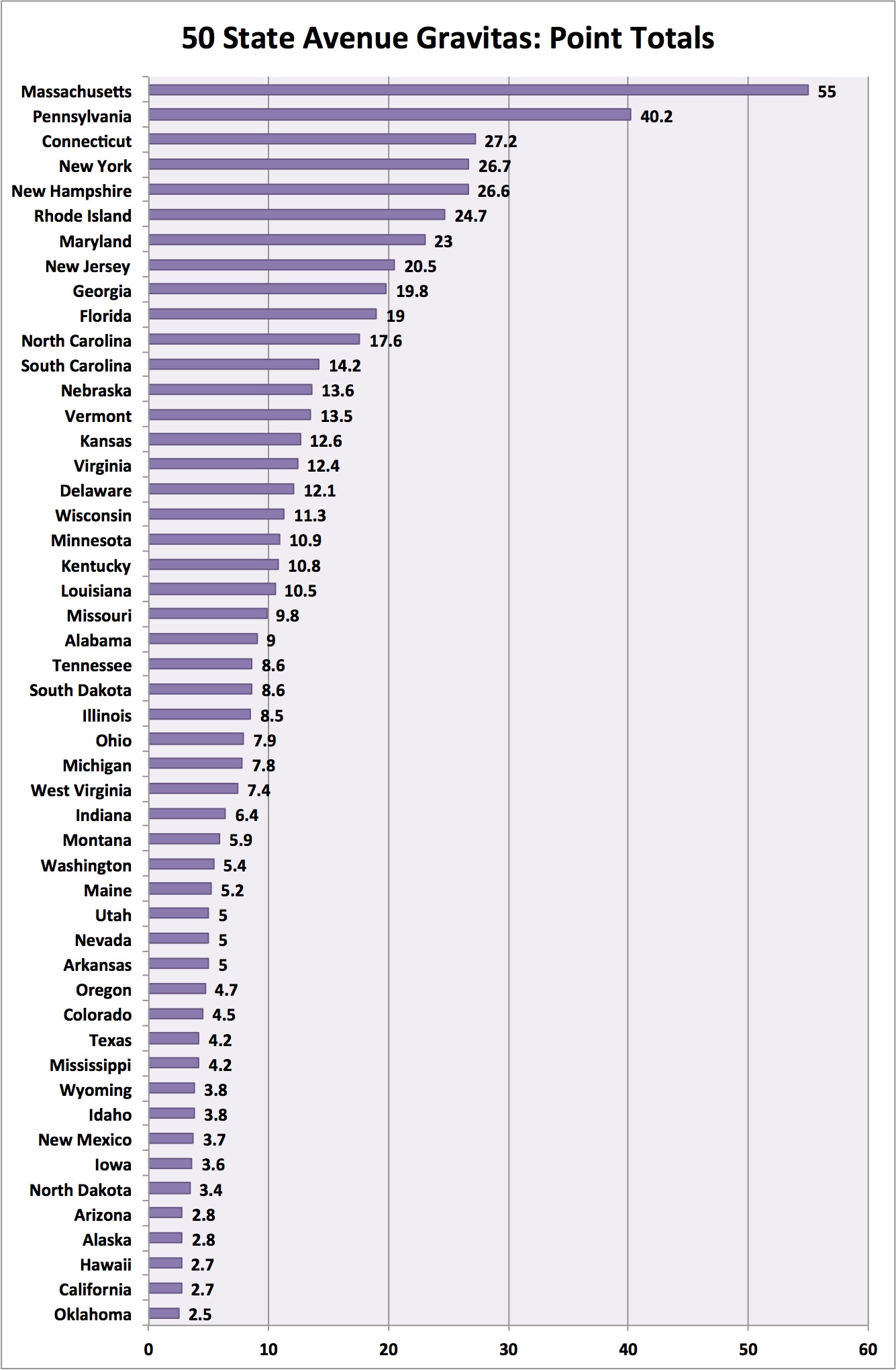
So it shouldn’t be a surprise that the states in the “Original 13” and/or were lucky to end up with a longer-mileage thoroughfare have a clear advantage in measuring state-avenue gravitas: Massachusetts (55), Pennsylvania (40.2), Connecticut (27.2), New York (26.7), New Hampshire (26.6), Rhode Island (24.7), Maryland (23), New Jersey (20.5), Georgia (19.8) and Florida (19) are in the Top 10.
Gravitas vs. Population
So, taking those tabulations, how can you determine whether a state’s D.C. state avenue gravitas is roughly proportional to the state’s population? This brings this exercise back full circle to the teenager on Pennsylvania Avenue asking about where Texas Avenue was. Certainly, every state is important in its own special way, but if there was some future pressing discussion at a future National Governors Association gathering where D.C.’s state avenue locations would be reallocated, how would that be determined equitably?
That’d be a doozy of a discussion and imagine the outrage from D.C. voting rights activists about such a misstep into local affairs. Nevertheless, you could factor in the number of Electoral College votes, which is a rough approximation of a state’s population.
So, if you divide a state’s D.C. state avenue gravitas point total by the state’s Electoral College vote total, you get a full spectrum of states that might be under-represented, over-represented or roughly equitable by their share of the national population. Here's what that looks like ... the higher numbers represent states that might be over-represented in D.C. considering their population. Look at the Granite State!
.jpg)
In this case, the top five, or the most over-represented, states are New Hampshire, Rhode Island, Massachusetts, Vermont and Wyoming—generally low population states and in the case of Massachusetts, it having D.C.’s longest state avenue by mileage and most intersections. New Hampshire and Rhode Island are in the top-five mileage states, too.
The bottom five, or the most under-represented, states are Illinois, Oklahoma, Arizona, Texas and California. For the bottom two, having the highest state populations doesn’t help their gravitas, but California and Texas having relatively obscure District locations doesn’t help, either.
And the states with D.C. avenues that are more or less fitting to their population size? The middle 10 are: North Dakota, Wisconsin, North Carolina, Minnesota, Alabama, Missouri, Virginia, Idaho, Alaska and New York.
Now, with this information, we can go about our more important work.
Editor's Note: The point totals chart has been updated to include the state of Oklahoma, which has been mistakenly left off the chart.
Michael Grass is Executive Editor of Government Executive’s Route Fifty. He’s the founding co-editor of DCist and previously served as Deputy Managing Editor at Washington City Paper, Washington D.C. Editor at The Huffington Post, Local Editor at The Washington Post’s Express and a Copy Editor at Roll Call.
NEXT STORY: Airbnb vs. the Hotel Industry: Big Lobbying and Influence Skirmishes Play Out in States and Localities